Willerby Walks: The best walks on Ynys Môn
24 April 2019With 140 miles of breath-taking coastline and a third of the island designated as an Area of Outstanding Natural Beauty (AONB), Anglesey is an unspoilt haven for walkers.
Wildlife is abundant, from seabirds to seals, dolphins and porpoises, which can often be spotted from the coastal path, and waders and wildfowl are common in estuaries.
Its ancient paths and stunning trails take in historical sites, castles, lighthouses and blue flag beaches where the sky meets the sea. And with so many scenic walks to choose from, where should you start?
We’ve picked out six of our favourite short and longer circular walks for you to try.
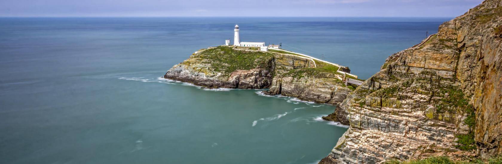
South Stack and Holyhead Mountain
This 5.5 mile (8.9km) circular walk guides you along the coastal path, taking in South Stack, North Stack and Holyhead Mountain.
Set out from Elin’s Tower car park and across heath to the coastal path. At South Stack, you will descend 400 steps to the lighthouse before following coast path signs towards Holyhead Mountain.
Look out for peregrines, seals, gannets and porpoises as you make your way along the coast and down to North Stack before climbing away from the coastal path and heading inland to round Holyhead Mountain.
Finish with coffee and cake at the RSPB Visitor Centre before heading back to the car park.
Nearby holiday parks include Porthdafarch Site, Blackthorn Farm, Tyn Towyn Caravan Park, Bagnol Caravan Park and Gwynfair Caravan Park.
To download a map of the full route visit here.
Ynys Llanddwyn
A number of waymarked trails run from various car parks in the Newborough National Nature Reserve, ranging from the 1 mile Nature and Puzzle Trail to the 5 mile Saint, Sand and Sea route.
The Saint, Sand and Sea route starts at the beach car park and takes in Newborough forest, the dunes and the island.
Ynys LLanddwyn is associated with the Welsh patron saint of love, Santes Dwynwen, and this route passes the remains of her church on the way to the lighthouse before looping back to the car park.
Ynys Llanddwyn can be cut off in high tides so check tide times before starting this route.
Other waymarked routes include the 2.5 mile (4km) Princes and Pines Heritage Trail, 1.5 mile (2.4km) Red Squirrel Trail, 1.5 mile (2.4km) Estuary View Walk and 3.7 mile (6km) Dune Walk.
Beaumaris Castle
Regarded by many as the finest of all the great Edwardian castles in Wales, Beaumaris Castle is a 13th-century unfinished masterpiece, a perfect example of a concentric castle and a World Heritage Site.
After exploring the castle, you can enjoy a walk along the coastal path towards Fryars Bay, with views over the Menai Strait towards Lavan Sands, Ceredigion and Snowdonia.
For more information visit here.
Dinas Gynfor from Cemaes Bay
This 4 mile (6.4km) walk explores the most northerly part of the Anglesey Coastal Path and returns via an inland footpath.
Set out from a small car park on the beach along the waymarked footpath, climbing steeply up rough steps before following the cliffs around a small headland.
The route leads to Llanbadrig, (The Church of St Patrick) and Dinas Gynfor, the most northerly point of Wales, and the site of an Iron Age hill fort.
After taking in the views, continue eastwards and join a path rising from Hells Mouth before dropping steadily back down the hillside and crossing a marsh on a stone causeway. A series of lanes, stiles and footpaths then lead you back to your starting point.
If you’re looking to stay in the local area, you can find accommodation at nearby Waen Farm Caravan Park.
Print out step by step route details here.
Llangefni
The Dingle Local Nature Reserve offers 25 acres of wooded valley to explore. Recent enhancements include a wooden boardwalk that winds its way along the Cefni river, three new bridges, sculptures, sculpted benches and picnic tables.
The reserve is home to ancient woodland, a carpet of bluebells and wildlife including kingfishers, moorhens, woodpeckers, foxes, bats and dragonflies.
With plenty of paths to choose from, you can make your walk as long or as short as you want to.
Directions and more information are available here.
Moelfre
Moelfre is a picturesque village with spectacular beaches, a working lifeboat and plenty of maritime history.
This 4.7 mile (7.6km) circular route follows a section of coast known as the ‘shipwreck coast’, due to the numerous wrecks that have taken place in its treacherous waters. The path passes the original 19th-century lifeboat station and slipway in front of the RNLI visitor centre, leading on to Moelfre’s new lifeboat station and then follows the coastal path on to the Royal Charter monument.
Further along the coastal path, you will reach Traeth Llgwy beach where you will leave the coastal path and head inland towards Hen Gapel Lligwy, a landmark ruin with spectacular views across the bay.
You will then continue to Din Lligwy, an ancient fortified settlement that dates back to the Iron Age, and on to Lligwy burial chamber before heading back to the starting point at the village car park.
Moelfre has a huge choice of holiday parks nearby, including Tyn Rhos Caravan Park, Pwll Coch Caravan Park, Melin Rhos Caravan Park, Minffordd Caravan Park, Capel Elen Caravan Park, Tyn Ffrwd Caravan Park, Tyddyn Isaf Caravan & Camping Site, Home Farm Caravan Park, Glanrafon Uchaf Caravan Park, Marianglas Caravan Park, Pigeon House Caravan Park and Penrhyn Point Holiday Site Anglesey.
More information, step by step route details and a map can be found here.
Where to stay in Anglesey
Anglesey is a popular region for holiday homes thanks to its breath-taking scenery and beautiful coast. With a Willerby holiday home (static caravan) or lodge, you could explore every walk in the area with a home away from home and the freedom to visit whenever you like.
To explore all our parks in Anglesey try our park finder tool here or for more information contact our friendly team here.